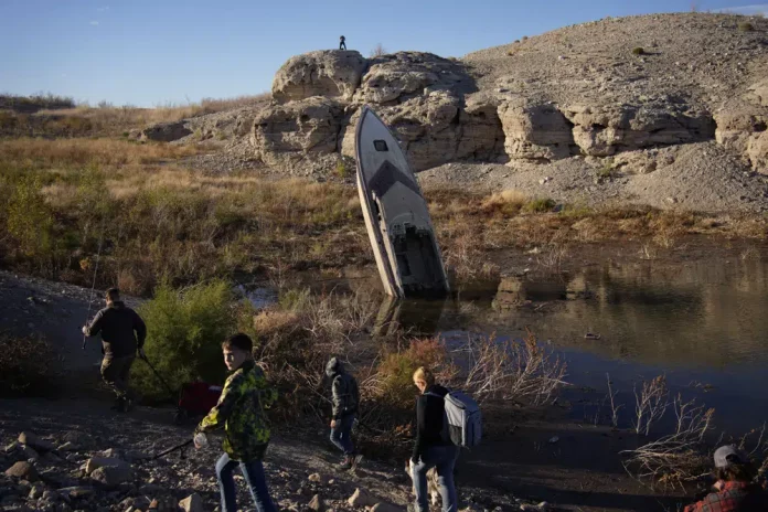
Exposed to the beating sun and hot dry air, more than 10% of the water carried by the Colorado River evaporates, leaks or spills as the 1,450-mile (2,334-kilometer) powerhouse of the West flows through the region’s dams, reservoirs, and open-air canals.
For decades, key stewards of the river have ignored the massive water loss, instead allocating Arizona, California, Nevada, and Mexico their share of the river without subtracting what’s evaporated.
But the 10% can no longer be ignored, hydrologists, state officials, and other western water experts say.
The West’s multi-decade drought has sent water levels in key reservoirs along the river to unprecedented lows. Officials from Nevada and Arizona say that they, together with California, now need to account for how much water is actually in the river.
The challenge is in finding a method that California also agrees to.
“It’s very hard to get consensus,” said Sarah Porter, director of the Kyl Center for Water Policy at Arizona State University. She thinks it’s unlikely that states will reach an agreement on their own without federal intervention.
Unlike Arizona, California, Nevada, and Mexico, the upriver or Upper Basin states — Colorado, New Mexico, Utah, and Wyoming — already take into account evaporation losses.
Now with a looming federal deadline for Colorado River basin states to say how they’ll use at least 15% less water from the river, there’s renewed urgency for Arizona, California, and Nevada to factor in what’s lost to evaporation.
One proposal comes from Nevada: States at the end of the river would see their Colorado River portion shrink based on the distance it travels to reach users. The farther south the river travels, the more water is lost as temperatures rise and water is exposed to the elements for longer.
The Southern Nevada Water Authority estimates that roughly 1.5 million acre-feet of water are lost to evaporation, transportation, and inefficiencies each year in Arizona, Nevada, and California. That’s 50% more than Utah uses in a whole year.
Nevada and Arizona could be on board with this plan.
Nevada stands to lose the least under this plan since Lake Mead — the man-made reservoir from which Arizona, Nevada, California, and Mexico draw water — sits in its backyard.
Tom Buschatzke, director of Arizona’s Department of Water Resources, called Nevada’s proposal fair.
“Calculating the losses as Nevada has proposed is probably the most equitable and matches the real, physical world,” Buschatzke said. “The further you are, the more the losses are.”
But crucially, California disagrees. Officials there have said Nevada’s plan would likely run afoul of western water law. California has rights to the largest share of Colorado River water. Just as important, in times of shortage, water cuts come later than for other users, based on the so-called Law of the River, a series of overlapping agreements, court decisions, and contracts that determine how the river is shared. Its senior water rights mean it has been spared from cuts so far.
California water managers have said evaporation and system losses should be accounted for based on this existing system. In a December letter to federal officials, Christopher Harris, executive director of the Colorado River Board of California, said any other approach could “face considerable legal and technical challenges.”
For Arizona, that could mean shouldering losses so significant that some experts say the drinking water supply for Phoenix could be threatened due to diminished deliveries to the Central Arizona Project, the 336-mile (541-kilometer) aqueduct system that delivers Colorado River water to that metro area and Tucson.
Under Nevada’s plan, California would pay a steep price. In addition to using more water from the river than any other state, its water travels some of the longest distances. California’s Imperial Irrigation District, the single largest of all users of Colorado River water, would lose about 19% of its share. The region grows many of the nation’s winter vegetables and alfalfa, and Imperial has said it disagrees with issuing water cuts according to evaporative losses at all.
Tina Shields, water manager for Imperial Irrigation District, said Arizona and Nevada — whose water rights are more junior than California’s — were advocating for the Southern Nevada Water Authority’s plan because it would benefit them to share the losses.
“When you have a junior, right, that’s what you do,” Shields said. “You try to share the problem with other users.”
According to John Fleck, a researcher at the University of New Mexico’s Water Resources Program, Lower Basin states have avoided recognizing these losses for so long in part because there was no need to in decades past. Water was plentiful, and some states didn’t take all the water to which they were legally entitled.
In many cases, the infrastructure needed to deliver water — vast canals, dams, and waterways — did not exist.
“The problem goes back to when … no one needed to care about this issue,” Fleck said.”
The difficult politics involved have also made the issue somewhat untouchable, Fleck said.
“No one was willing to take it on,” Fleck said. “It all comes down to the same thing: you have to take less water out of the system.”
Republished with permission of The Associated Press.


